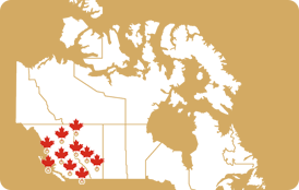
Kimberley is located in the south eastern corner of British Columbia just north of the U.S. Border. It is 24 km (15 miles) northwest of the city of Cranbrook.
From Kimberley, you can enjoy views overlooking the fertile and beautiful Kootenay River Valley and the Rocky Mountains to the east. Kimberley also receives great weather - Cranbrook, located just 20 minutes south of Kimberley, gets the most hours of sunshine of anywhere in British Columbia!
With an elevation of 1,116 meters (3,662 feet), Kimberley is one of the highest cities in Canada. It is the site of the Sullivan mine, one of the world's largest lead and zinc producers. The mine’s owner, the prospector Pat Sullivan, founded the city of Kimberley when he staked his claim there in 1892. Originally called Mark Creek Crossing, it was renamed Kimberley in 1896 and incorporated as a city in 1944.
As well as the many shops and restaurants Kimberley has to offer, other attractions include the Marysville Falls, Cominco Gardens, Bavarian City Mining Railway and the largest cuckoo clock in Canada!
For the active, in the winter there is nearby Kimberley Alpine Ski Resort, and in the spring, summer and fall months there is the Trickle Creek Golf Resort, Bootleg Gap Golf, Kimberley Golf Club, Kimberley Nature Park and the Kimberley Riverside Campground.
Kimberley also hosts yearly festivals including the International Old Time Accordion Championship - (always second week in July), the July-fest - (third weekend in July) and the International Music and Dance Festival (Labour Day Weekend).


